In just over two months I'll be making my way to New Haven, CT to begin my journey across the country with my fellow Bike & Builders. With the weather improving gradually every weekend I've been able to get out and ride more. The trails surrounding DC are great, but I can't help but think about what lies ahead. The opportunity to experience our beautiful country in such a unique way has me absolutely giddy!
That said, I spend a lot of time thinking about and researching my route, especially the parts in Colorado and Utah, two states in which I've never been and am so excited to travel through! I quickly realized that the Connecticut to California route map shown on the Bike & Build website (and shown here on the C2C Route tab) does a pretty good job of showing the general route, but I wanted to create something a bit more detailed and informative, being the lover of maps that I am.
I decided to take a stab at mapping my route on a ride planning website so I could see my route in more detail (and with an elevation map!). I used the daily stopping points and the projected daily mileage to come up with the map shown below. The exact routes between each town are probably not completely accurate, but I did my best with the information I had on hand. The craziest part to me is visually seeing the elevation differences between the east coast and the west coast. I mean I knew the Rockies were much bigger than the Appalachians, but I didn't realize they were THAT much bigger! The Rockies (and pretty much the entire west coast for that matter!) make the Appalachians look like a measly hill in comparison. When biking through the Appalachians we reach a max elevation of about 3,600 feet, but in the Rockies we'll be over 12,000 feet with those ups and downs continuing all the way through to California. Guess it's time to get my gams ready for some inclines (and my eyes ready for some incredible scenery)!
If you are a map nerd like me, the link below allows you to explore my route even more. You can zoom in and check out specific segments of my route and even use street view to see what kind of views I might be encountering along the way! Also let me know if I'll be passing near you at any point along the trip - I'd love to meet up with people if I have the chance!
http://ridewithgps.com/routes/7029890
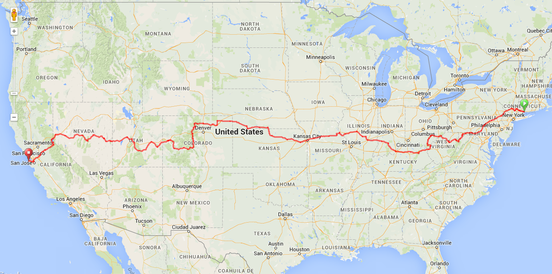
Connecticut to California Route
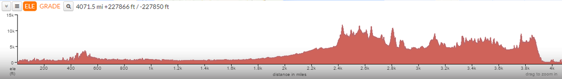
Elevation Map (From East to West)


 RSS Feed
